

- Home
- Companies
- OroraTech GmbH
- Software
- OroraTech - Satellite-Based Wildfire ...
OroraTech - Satellite-Based Wildfire Burnt Area Assessment Software
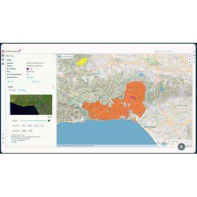
OroraTech offers an advanced Burnt Area Mapping Solution that leverages high-resolution satellite data to provide precise and swift assessments of wildfire damage across the globe. The system is designed for rapid analysis, delivering critical fire damage data within 2-3 days of a wildfire event. This enhances speed and accuracy, enabling efficient resource allocation and minimizing recovery times and costs compared to traditional ground-based surveys. Operating at a spatial resolution of up to 20 meters, the product ensures high precision, even in remote or challenging locations, and tracks fire progression with detailed timestamps. It’s equipped with an automated and scalable detection system, providing a cost-effective alternative to aerial mapping. This solution aids various sectors such as civil protection, infrastructure, forestry, and carbon management in fast post-fire responses, comprehensive impact assessments, and transparent communication with stakeholders, supporting an integrated approach to managing wildfire recovery and resource planning.
Precision, speed, confidence
Your post-fire strategy starts here
Our Burnt Area solution delivers fast, reliable, and highly detailed insights into fire damage globally, helping you drive recovery efforts and make informed decisions in the aftermath of wildfires.
Global coverage, local precision
Get accurate, high-resolution fire data worldwide with 20-meter precision – even in remote or challenging locations.
Fast turnaround – data within days
Receive critical fire damage data within 2-3 days of a fire event to accelerate recovery planning and minimize costs.
100% automated detection
Save time and costs with a scalable, fully automated system that detects and maps burnt areas instantly.
Detailed burn severity assessment
Assess the severity of the damage to maximize the efficiency of your recovery efforts and resource allocation.
Cost-effective alternative
Replace expensive aerial mapping with a faster, more affordable satellite-based fire damage assessment.
Meta information for enhanced analysis
Track fire progression with precise timestamps, enabling better mitigation and recovery planning.