

- Home
- Companies
- Lakes Environmental Software
- Software
- Lakes Environmental - Version Aerscreen ...
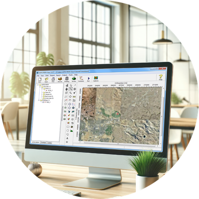
Lakes Environmental - Version Aerscreen View 4.0 -Screening Air Dispersion Modeling Software
AERSCREEN View is a user friendly interface for the U.S. EPA AERSCREEN screening-level air quality model and associated modeling programs. AERSCREEN estimates worst-case impacts of ground level concentrations for a single source by interfacing with the screening mode of the AERMOD model. Scenarios can include simple or complex terrain, building downwash, and NO2 chemistry.
AERSCREEN View incorporates features designed by experienced meteorologists and engineers who routinely work with air dispersion models. This ensures it meets the practical needs of today`s modelers for successful and efficient performance.
Fully integrated GIS-based interface combining easy to use graphical tools.
Allows you to quickly and easily set up modeling scenarios in AERSCREEN.
Advanced terrain processing capabilities are offered for several terrain data file formats.
We’re here to make things easy! Here’s a list of everything included with your software purchase:
AERSCREEN View is an interface for the AERSCREEN US EPA air dispersion model.
- Model Name: AERSCREEN
- Developed by: United States Environmental Protection Agency (US EPA)
- Model Type: Steady-state Gaussian plume screening-level air dispersion model (interfaces with the AERMOD model)
- Range: Up to 50km from the source
- Atmospheric Stability Model: Planetary boundary layer theory, turbulence scaling concepts
- Release Types: Buoyant or neutrally buoyant plumes
- Emission Types: Constant or planned or fugitive
- Atmospheric Chemistry: NOX to NO2 (OLM and PVMRM methods)
- Source Types: Point, area, volume, flare*
- Meteorology: Site-specific matrix of meteorological conditions generated by MAKEMET
- Terrain: Flat or elevated terrain (preprocessed by AERMAP)
- Receptors: Automatically-generated receptor array out to user-defined maximum downwind distance and up to 10 discrete receptor distances
- Other Options: Building downwash (modeled by BPIP-PRIME)
- Regulatory Status: Preferred US EPA regulatory model for near-field applications