

- Home
- Companies
- Leraand Engineering Inc. (LEI)
- Software
- SonarTRX - Sidescan Sonar Processing ...
SonarTRX - Sidescan Sonar Processing Software
The main focus of SonarTRX software is the generation of geo-referenced raster images from sidescan sonar recordings. SonarTRX can also be used to extract depth (echo soundings) from these recordings, for bathymetric processing with GIS or 3`rd party terrain processing utilities. SonarTRX can be part of a very affordable tool-kit for exploring & mapping the seabed from your kayak, jet ski or small boat.
- General shallow-water sidescan surveys
- Mapping of fishing areas
- Locating interesting scuba dive-sites
- Locating shallow-water marine debris for later cleanup
- Archaeology: Mapping of underwater archaeological sites
- Treasure hunting (ship wrecks, sunken boats,...)
- Marine habitat mapping, underwater ecology
- Search and rescue
- Costal Engineering surveys
- Pipeline and cable landing surveys
- Port and harbor security
SonarTRX supports recordings from the most affordable sidescan sonars available, including fishfinder-style products such as Humminbird sonars with Side Imaging, Lowrance StructureScan and Garmin SideVu. SonarTRX also supports generic XTF files from sidescan towfish, StarFish XTF and vendor-specific recordings from SportScan & YellowFin towfish (by Imagenex) and DeepEye 340 towfish (by DeepView.)

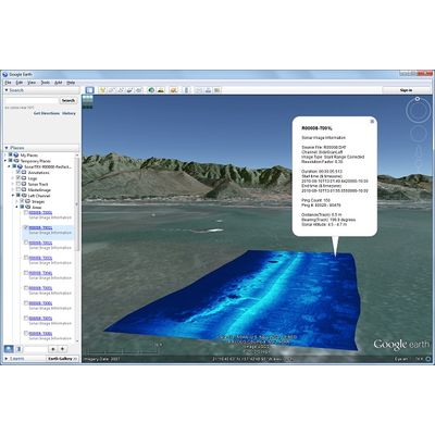
The screen-capture of the SonarTRX viewer (above) and the mosaic image below is from an area with coral reef patches and sand channels with sand waves. The above picture shows a very "noisy" environment above the reef as compared to the sand channels. It was recorded from a kayak using hardware & software costing < ~ $2,500 (U.S). (Note: Even lower cost sonars are available, making it possible to do sidescan surveys for a litte more than $1,000, including hardware & software.) The slant range corrected, geo-referenced image below is generated by SonarTRX from a recording made from a kayak, using a Humminbird 998c-SI. It shows sand channels with wave ripples between patches of coral reef:
