
- Home
- Companies
- Roadscanners Oy
- Software
- Road Doctor - Version 3 - Surface and ...


Road Doctor - Version 3 -Surface and Sub-Surface Data Analysis Software, GPR
- Is designed especially for multi-year infrastructure survey’s and asset management
- Is a unique and powerful software for simultaneous surface and sub-surface data analysis
- Can synchronize and visualize data from several sources enabling multidata analysis
- Is an excellent tool for presenting results in visual and informative way
- Is scalable and compatible – includes support of a wide array of survey devices and data formats. If something is missing – it can be added.
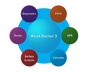
- Can be complemented by 6 different modules to cover road, street, airport runway, bridge and geological applications.
- Is based on a 64-bit multiprocessor architecture, which allows more memory and faster calculation of big amounts of data e.g. in point cloud and GPR 3D views.
The “CORE” is a basic part of Road Doctor for every user either engineer, geophysicist, or geologist.
For many customers “CORE” may be all that is needed to get started with multidata analysis. It includes operations for linking almost all RD supported data types and doing basic manual data-analysis and feature digitizing. It brings together in the same synchronized view GPR, Map, Point-cloud, Video, 360 Video, Ground truth, Falling weight, Profilometer, Data-base, and other data.
It includes tools for example Government and municipal engineers administrating the roads to create and look predefined views and output most valuable results for decision makers.
Interface 3.4 with Help and Video
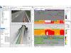
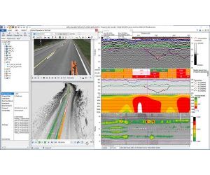
Image demonstrating use of several synchronized videos with a data view at the same time. Ribbon bar shows activated tool buttons. After bringing the data view and videos on the screen, the views were linked by pressing button “Link Views” and arranged automatically by pressing “Arrange Linked Views” button. “Link Video functions” button sets the videos also start and pause synchronized. The view was saved and loaded again and all settings were automatically set. GPR data and remission data with rutting data are shown in Data view. Pressing F1 -key has brought Road Doctor Help text on the screen.
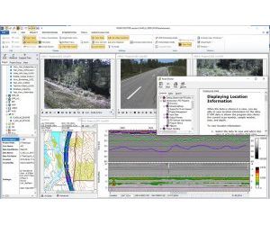
A view showing some major elements for Road Condition analysis, Video and rutting map displaying the surface condition, Ground Penetrating Radar data and Falling Weight data showing the structural condition. The point cloud data enables quick visualization of road geometry. The Rutting data and calculated moduli values are overlaid also in point cloud.

Diagnostics module is a set of tools for analyzing Road Survey data both automatically and manually. Specially designed for Road engineers, who want to compare data results from several years and do predictions of structures remaining life time and bearing capacity.

Design module is a special set of tools for Road engineers for doing quick rehabilitation design and new structure’s bearing capacity analysis.

Surface analysis module is a tool designed for Lidar, laser-scanner and accelerometer data handling. It is an excellent tool for road engineers for calculating the pavement surface and structural quality. It includes functions for calculating longitudinal (IRI) and cross-sectional road surface quality parameter (Rutting). Module brings also possibility to quickly link all Road Doctor Survey Van measured data to project batch operation.
Concrete module is a tool for finding out anomalies like arisen moisture and cracks in concrete structures like bridges, floors, walls etc. It uses amplitude and frequency analysis of GPR data as method. This tool is a good help for bridge engineers to check the bridge condition, for example.
Rock module is a specially designed tool for analyzing the extent of rock excavation zone. The method is based on analyzing the frequency and amplitude content of high frequency GPR antenna data. The tool helps rock engineers to estimate the integrity and stability of tunnel walls and roof. The module can be used also for general frequency content analysis of GPR Data.