
TerraMath
TerraMath - Geographic Information Systems (GIS) & Remote Sensing Software
FromTerraMath
Geographic Information Systems (GIS) are always 3D and 4D for us - as the earth is a 3D body moving through time (4D). Our interest is to deduct 3D geological information from remote sensing images and digital elevation data (DEM) and combine them with other datasets like outcrop data, well logs, geological profiles, seismic, geophysics to build 3D models for applications in exploration, mining, groundwater modeling and others. We start where other service provider stop! Our focus is to integrate new functions required by our clients. As we use our own software libs we do not depend on the functionality of other software vendors.
Most popular related searches
geographic information system
remote sensing
remote sensing software
geographic information
remote sensing image
GIS software
seismic geophysics
remote sensing data
geological data
well logging
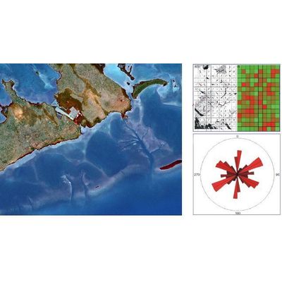
Remote Sensing is the science to retrieve information from a distant object.
- Image preprocessing and geocoding
- Experience of handling visible, infrared, thermal infrared, hyper spectral and RADAR images
- To be more flexible we use our own remote sensing / GIS software (WinGeol) but are open to use 3rd party products like ERDAS Imagine, ArcGIS, AutoCAD and may more if required