
TerraMath software
GIS & Remote Sensing
TerraMath - Geographic Information Systems (GIS) & Remote Sensing Software
Geographic Information Systems (GIS) are always 3D and 4D for us - as the earth is a 3D body moving through time (4D). Our interest is to deduct 3D geological information from remote sensing images and digital elevation data (DEM) and combine them with other datasets like outcrop data, well logs, geological profiles, seismic, geophysics to build 3D models for applications in exploration, mining, groundwater modeling and others. We start where other service provider stop! Our focus is to integrate new functions required by our clients. As we use our own software libs we do not depend on the functionality of other software vendors.
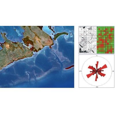
TerraMath FaultTrace - Model WinGeol Based - Trace Geological Faults Software
FaultTrace is used to trace geological faults or the outcropping of geological strata on the surface of the earth. In this way 3D information is gathered about these structures. This knowledge is mandatory for building accurate models of the subsurface as required in many applications (geothermal, mining, oil exploration, academic studies and others). We developed a Google Earth based version as well but as the user has limited control on the data used - the elevation data Google is using having much lower spatial resolution than the satellite images draped on it - we do not recommend this version for serious work as errors occur frequently. Nevertheless this tool might be ok for the one looking for a fast overview and is aware of the limitations.
3D Modeling
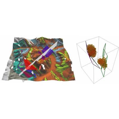
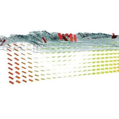
TerraMath - 3D Interpolation Software
This is the next logical step after gathering all geological / geophysical data. Modeling and interpolation means that we put the data in relation to each other. Geological systems are extreme complex and at the same time well hidden underground. Our goal is to provide functions to create as realistic models as possible. Geometric smooth models might look impressing and beautiful but often lack detail (except geometry) which are essential for the later application. We prefer to use VOXEL based approaches which are extended to store all relevant data for each location and not only at the volume surface. These 3D models are ready to support anisotropic properties. Because of this special situation we at TerraMath are convinced that in addition to standard interpolation methods numerical process modeling is absolute necessary - Dr. Faber has therefore developed the SedTec software.
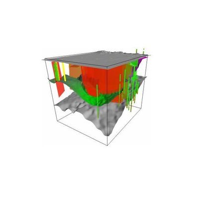
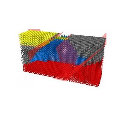
TerraMath - 3D Modeling Geology Software
For most applications 3D representations of the Geology are required nowadays. Our software & algorithms offer: Import of data like well logs, strike / dip, 2D sections (seismic or drawings) or lithological surface data. Constructing sections based on those data. Advanced 3D interpolation algorithms honoring strike/dip and faults.
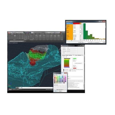
TerraMath - 3D Topology and Analysis Software
Automatic extraction of information from 3D data sets. Functions added to WinGeol allow: Import of data derived from AutoCAD 3D solids (using MMT as middleware), STL and point cloud (in prep.) data. Triangulation and geometric topology. Rule based topology creation, extraction of surface areas defined by properties or property differences to neighboring areas. or of linear feature which define the boundaries between areas. Shape analysis (elongation, rounding, ...; in prep.).
Numerical Modeling
SedTec - Model WinGeol Based - Numerical Modeling and Simulation Software
SedTec (WinGeol based): Numerical simulation of erosion and sedimentation in dependency of topography, tectonic movements, lithological properties and sealevel. This software is based on WinGeol and therefore data preparations and visualization of results can be done within one software package. To compare simulation results with the real world situation virtual wells can be generated and profiles can be compared with section images (eg. seismic). As the in between calculation results are saved, the whole simulation sequence can be reviewed later.
Mining & Energy
TerraMath - Model MMT - Documentation, Analysis, Modelling and Visualization of Mining Activities Software
is designed for the documentation, analysis, modelling and visualisation of mining activities. The software runs inside the industry standard AutoCAD and can take advantage of all its functions. A relational database system - like MySQL or PostgreSQL - is used to store all project relevant data. Using MMT is not forcing you into a certain scheme - the base software will be configured to fit perfectly to your existing workflow and demands. MMT is used so far by mining companies in Germany and Austria, especially for mass raw material and salt solution mining. If you are located in Austria or Germany, please contact: Marschallinger Geoinformatik.
Hardware/Sensor

TerraMath - Sensors for Education and Research Software
Sensors help us to collect data of our environment. They are the link between nature and our theoretical models / simulations of it. Sensors are a great way to learn about nature - independent of the age of the students. On one side live experience and measurement deepens the understanding of natural processes and their relationships to each other on the other side it promotes interest in technology! We design solutions and experiments for school classes, own educational programs and up to university research.