

Pix4D SA
Version PIX4Dcatch RTK Workflow -Terrestrial 3D Scanning With Rtk Survey-Grade Accuracy
FromPix4D SA
Use PIX4Dcatch and the viDoc RTK rover to document trenches. See how you can digitize and accurately document trenches and as-builts on construction sites. Capture: Use your smartphone with the PIX4Dcatch mobile app to capture the asset. Add an RTK device to it, to improve your accuracy. Process: Upload your images automatically to PIX4Dcloud for seamless processing OR import your images from the phone to the PIX4Dmatic desktop app, using the PIX4Dcatch processing template. Export to CAD/BIM/GIS: Mark your assets on PIX4Dsurvey as vectors in the pointcloud and export them as DXF (for CAD) or SHP (for GIS).
Most popular related searches
Accurate surveying from your mobile device
Easy field-to-finish workflows
Easy digitalization with Pix4D software that can measure single points or create line work from data capture.
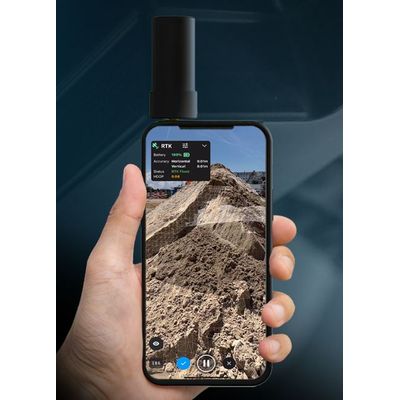
RTK positioning rover for 3D scanning
viDoc RTK rover pairs with the PIX4Dcatch to geotag images of the 3D scan in real-time using NTRIP services.
Enhanced mobile data collection
viDoc connects to over 600 channels (including all major constellations such as GPS, GLONASS, Galileo, etc.) which results in convergence in under 5 seconds.
Replacing complex workflows
Ground surveying equipment like laser scanners can be expensive, bulky, and highly technical. Drones can be restricted by regulations. Overcome the obstacles with a handheld rover.
A complete, accurate workflow in your hands
The viDoc, the smartphone, PIX4Dcatch, and PIX4Dcloud. An end-to-end solution that gets measurements at centimeter level absolute accuracy.
Intuitive feel and structure
Easy for anyone to collect points or complete an accurate 3D scan. The handheld rover combines with mobile software to create digital twins as fast as possible.