

- Home
- Companies
- Advanced Geophysical Operations and ...
- Software
- Version ZondST3D - Seismotomography 3D ...
Version ZondST3D -Seismotomography 3D Data Interpretation Software
ZondST3D is designed for 3-D data processing and interpretation for seismic tomography by method of refracted waives. There are several options: Ground profiles (3D); Down hole; Water surface.
3-D seismic tomography technique involves a special method of measurement using large number of source-receiver positions. But in many cases for 3-D interpretation is sufficient to use 2-D inversion on several parallel profiles.
ZondST3d is a solution for seismic tomography, and it solves a wide range of problems from mathematical modeling and sensitivity analysis, to field data processing and interpretation. User-friendly interface and extensive reporting capabilities allow the most efficient way to solve the geological problems.
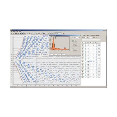
The program is divided into two main modules. The first is to dive the first arrivals (correlation) on the seismograms. The second is used for solving direct and inverse three-dimensional seismic tomography.
For processing of seismograms developed a special interface designed to simplify and automate the process of diving first arrivals. Foundation focuses on a variety of ways to visualize and access to frequently used functions.
In solving the direct problem of ray tracing using a special algorithm of graph theory (Shortest path`s method). This algorithm is fast and controlled accuracy of calculations.
ZondST3d uses a simple and understandable data format that allows you to easily combine different observing systems, including various options for topography description and other priory information. Some well-known data formats are also supported.
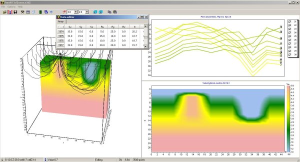
The program provides several options for displaying three-dimensional medium in the form of different slices and underground topography contour lines.
Since the main objective is to restore the parameters of velocity profile - ZondST3d provides several options for solving the inverse problem, the most important of which are: the smoothing inversion - for smooth, block for block and focusing, for piecewise smooth distribution of the velocity parameters with depth.
The program focuses on the integration of a priori information. Due to the equivalence of inverse geophysical problems, the quality of the results depends on the amount used as priori data. In ZondST3d there are options for weight measurements, fixing and setting limits changes in the properties of individual cells, using a priori model as reference for the inversion. In addition, the program implemented a robust evaluation framework of the noise component. It is also possible to import and display the results of measurements by other methods as well as borehole data, which contribute to a more integrated approach to data interpretation.