

IDSi International
- Home
- Companies
- IDSi International
- Software
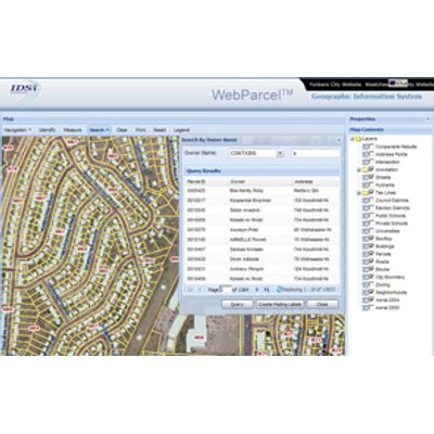
- WebParcel - .NET with ArcGIS Server
Most popular related searches
The WebParcel™ links your Parcel Database with an easy-to-use mapping application with new, easy-to-use features that save you time and resources. Features like identifying all parcels within a user-defined area are made easy through a few clicks. The WebParcel™ serves up Appraisal Cards and enables you to define and print mailing labels within a few clicks. The user-friendly application can be rapidly implemented or can be hosted to save you hardware/software license costs. The WebParcel™ requires minimal training for non-GIS users and is completely accessible through a simple browser
- Robust and scalable to handle many users.
-
Built on open standards and flexible to handle customizations.
- Built on latest .NET technology.
- Harnesses the ArcGIS Server platform.
- Web Services capable so that you can integrate external services.
-
Create a buffer of user-defined distance around a selected Parcel and generate/print Mailing Lists
-
Search by Owner Name, Street Address, or Parcel ID
-
Search Results are displayed as a sorted list
-
Generate or Print Property Record and Appraisal Cards
-
View tax assessor details of any selected property
-
Display photographs of any selected property
-
Interactively select multiple parcels
-
Easily Print Maps of selected properties