

- Asset Performance Software
- Piping and Vessel Design Software for Nuclear Plants
- Green Building Design Software
- Svoffice 2009
- AutoPLANT - 3D Plant Design and Modeling Software
- Nuclear Plant Design and Modeling Software
- Communications GIS and Network Engineering Software
- Environmental Regulations Software
- ConstructSim - Advanced Work Packaging and Systems Completion Software
- ContextCapture - Reality Modeling Software
- Descartes
- gINT - Geotechnical and Geoenvironmental Software
- Hevacomp - Building Energy Analysis Software
- iTwin Services Subscription
- LARS - Bridge Load Rating Modeling and Analysis Software
- LEAP - Concrete and Steel Bridge Design and Analysis Software
- LEGION - Simulation and Modeling Software
- LumenRT - Visualization and Reality Modeling Software
- Maxsurf - Maximize Vessel Performance
- MicroStation - Modeling, Documentation, and Visualization Software
- MineCycle - Mine Design and Mine Planning Software
- Moses - Integrated Offshore Simulation Software
- Navigator - BIM Review and Issue Resolution Software
- OpenBridge - Design, Modeling, and Analysis Software for Bridges
- OpenBuildings - Building Design and Energy Analysis Software
- OpenCities Map - Engineering-quality GIS and Mapping Software
- OpenCities Planner - City-Scale Digital Twin Planning and Visualization Software
- OpenFlows - Hydraulics and Hydrology Software
- OpenPlant - Interoperable 2D and 3D Plant Design Software
- OpenRail - Civil Design Software for Rail Networks
- OpenRoads - Civil Design Software for Road Networks
- OpenSite - Civil Site Design Software
- OpenUtilities - Utilities Network Design and GIS Software
- PlantSight
- PlantWise - 3D Process Plant Design Software
- PLAXIS - Geotechnical Finite Element Analysis Software
- Pointools - Point-Cloud Processing Software
- ProcureWare - Efficient and Transparent Sourcing Solution
- ProjectWise - Digital Environment
- Promis.e - Electrical and Control System Design Software
- ProStructures - Steel and Concrete Design Software
- RAM - Structural Design Software for Buildings
- RM - Bridge Design, Analysis, and Construction Software
- SACS - Offshore Structural Analysis and Design Software
- SoilVision - Geotechnical Software
- STAAD - 3D Structural Analysis and Design Software
- Superload - Automated Vehicle Permitting and Routing Software
Bentley Systems, Incorporated software
Communications GIS and Network Engineering Software

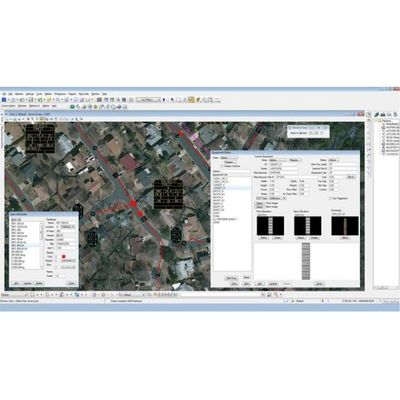
Bentley Coax - Network Design and GIS Software

Bentley Fiber - Fiber Network Design and GIS Software
Design and document your outside plant fiber network faster with Bentley Fiber. Attract and retain more subscribers when you deploy upgrades, activate new service, and restore faults more quickly. Layout and verify FTTx, HFC, and other architectures fast in an engineering GIS with real-time signal calculations. Speed field and office workflows by sharing an intelligent network model across your enterprise.
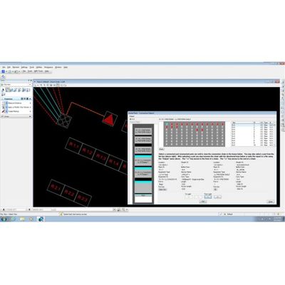
Bentley - Inside Plant Network Design Software
Get fast and precise design and documentation of your network facilities with Bentley Inside Plant. Speed projects with visual layout of headends, points of presence, central offices, data centers, and other sites. Get consistent designs and save time with common equipment, layout templates, connection rules, and standard reports. Speed field and office workflows by sharing an intelligent network model across your enterprise.
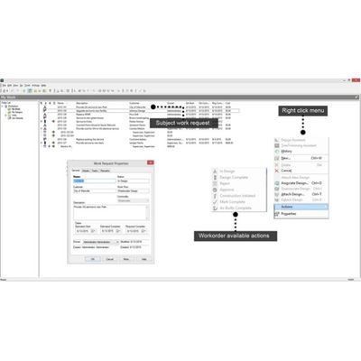
Bentley - Network Design Workflow Management Software
Increase engineering throughput by merging network design and work management with Bentley Expert Designer Communications. You can reduce budget and schedule risks with streamlined project management from start to finish. Speed projects with seamless management of work performed in-house or by contractors working outside your network. Keep up with demand for new services and network performance with faster designs, reviews, and approvals.
Bentley PowerView - Communications Network GIS Software
Make your network field staff more productive and improve service with Bentley Communications PowerView software. Speed work orders and reduce errors by putting end-to-end network maps, equipment records, and data capture tools at the fingers of field workers. Abandon your out-of-date paper maps and ensure access to precise network records anytime and anywhere, even without a wireless connection.