

- Asset Performance Software
- Piping and Vessel Design Software for Nuclear Plants
- Green Building Design Software
- Svoffice 2009
- AutoPLANT - 3D Plant Design and Modeling Software
- Nuclear Plant Design and Modeling Software
- Communications GIS and Network Engineering Software
- Environmental Regulations Software
- ConstructSim - Advanced Work Packaging and Systems Completion Software
- ContextCapture - Reality Modeling Software
- Descartes
- gINT - Geotechnical and Geoenvironmental Software
- Hevacomp - Building Energy Analysis Software
- iTwin Services Subscription
- LARS - Bridge Load Rating Modeling and Analysis Software
- LEAP - Concrete and Steel Bridge Design and Analysis Software
- LEGION - Simulation and Modeling Software
- LumenRT - Visualization and Reality Modeling Software
- Maxsurf - Maximize Vessel Performance
- MicroStation - Modeling, Documentation, and Visualization Software
- MineCycle - Mine Design and Mine Planning Software
- Moses - Integrated Offshore Simulation Software
- Navigator - BIM Review and Issue Resolution Software
- OpenBridge - Design, Modeling, and Analysis Software for Bridges
- OpenBuildings - Building Design and Energy Analysis Software
- OpenCities Map - Engineering-quality GIS and Mapping Software
- OpenCities Planner - City-Scale Digital Twin Planning and Visualization Software
- OpenFlows - Hydraulics and Hydrology Software
- OpenPlant - Interoperable 2D and 3D Plant Design Software
- OpenRail - Civil Design Software for Rail Networks
- OpenRoads - Civil Design Software for Road Networks
- OpenSite - Civil Site Design Software
- OpenUtilities - Utilities Network Design and GIS Software
- PlantSight
- PlantWise - 3D Process Plant Design Software
- PLAXIS - Geotechnical Finite Element Analysis Software
- Pointools - Point-Cloud Processing Software
- ProcureWare - Efficient and Transparent Sourcing Solution
- ProjectWise - Digital Environment
- Promis.e - Electrical and Control System Design Software
- ProStructures - Steel and Concrete Design Software
- RAM - Structural Design Software for Buildings
- RM - Bridge Design, Analysis, and Construction Software
- SACS - Offshore Structural Analysis and Design Software
- SoilVision - Geotechnical Software
- STAAD - 3D Structural Analysis and Design Software
- Superload - Automated Vehicle Permitting and Routing Software
Bentley Systems, Incorporated software
ContextCapture - Reality Modeling Software
ContextCapture - Reality Modeling Software
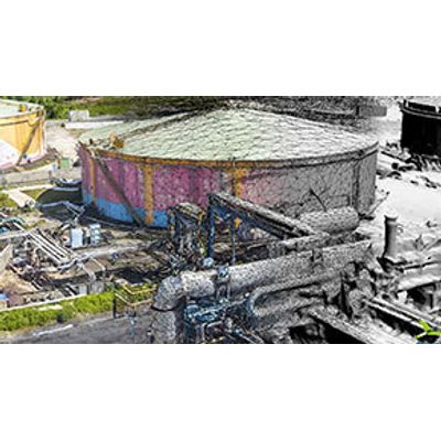
With ContextCapture, you can quickly produce even the most challenging 3D models of existing conditions for infrastructure projects of all types, derived from simple photographs and/or point clouds. Without the need for expensive, specialized equipment, you can quickly create and use these highly detailed, 3D reality meshes to provide precise real-world context for design, construction, and operations decisions for use throughout the lifecycle of a project. Hybrid processing in ContextCapture enables the creation of engineering-ready reality meshes that incorporate the best of both worlds – the versatility and convenience of high-resolution photography supplemented, where needed, by additional accuracy of point clouds from laser scanning.
ContextCapture Center - Reality Modeling Software
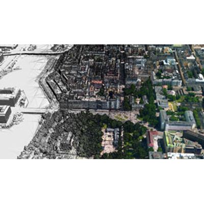
With ContextCapture Center, you can quickly produce even the largest and most challenging 3D models of existing conditions for infrastructure projects of all types, including scales as large as entire cities, derived from any digital photographs. It will provide support for the most sophisticated aerial camera systems, including UAVs acquisition systems and laser scanners. Without the need for expensive and specialized equipment, you can quickly create and use these highly detailed 3D reality meshes to provide precise real-world context for design, construction, and operations decisions for use throughout the lifecycles of projects.
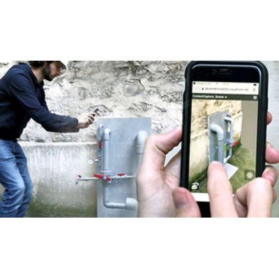
ContextCapture - Mobile App
Simplify and scale your projects allowing anyone on your team to easily document as-is situations affordably, with less investment of time and resources, reducing your costs with ContextCapture Mobile. ContextCapture Mobile allows you to quickly create and display 3D reality meshes using photos taken with your phone or tablet leveraging Bentley’s ContextCapture Cloud Processing Service. Your reality modeling data will be stored in ProjectWise ContextShare, a cloud service that extends Bentley’s Connected Data Environment. Reality meshes can be streamed to ProjectWise users for use in design, analytical, and construction modeling workflows.
ContextCapture Viewer - Viewing Software for Reality Meshes
With ContextCapture Viewer (also known as Acute3D Viewer), you can easily explore and precisely measure reality meshes of any scale created with Bentley`s ContextCapture software. You can easily switch on or off the display of the model to texture, hillshade, and wireframe to better understand existing conditions. Share beautiful visuals of your model with stakeholders and clients. You can easily produce movies with the intuitive time-based fly-through and object animation system or create high resolution screen captures of your 3D reality mesh.