
GAF AG services
Geoservices

Data Processing Services
Since 1985, efficient and reliable EO raster data processes have been the backbone of GAF’s wide range of services in a range of application fields. In the data processing unit, all experts have dedicated image processing and geo-science backgrounds. Over the course of many projects, we have processed vast amounts of data covering all parts of the globe and consisting of various commercial and scientific sensor data from optical and radar sources, as well as data from derived products such as digital elevation models. In recent years, GAF has built up dedicated and highly efficient workflows for the production of large quantities of very high resolution (VHR) satellite orthoimagery and large-area mosaics in order to serve the growing customer demand for such products.
Mapping and Monitoring Services
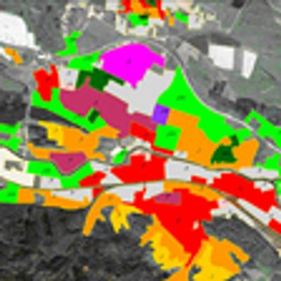
One of the key areas of GAF service provision is mapping and monitoring tasks carried out entirely or partially using earth observation and/or other types of geospatial data. The information extraction and derivation technologies used range from visual interpretation of pre-processed and spectrally/texturally enhanced raster information using ancillary data layers and calibration information to automated or semi-automated feature extraction workflows. A particular strength of GAF is the wide thematic data extraction and derivation experience, which includes the obtaining of data for applications in the fields of natural resources, infrastructure, land cover and land use, as well as all types of planning relevant information. GAF mapping projects typically cover large areas and thereby benefit to the maximum from the use of satellite information.
Information Systems Services
A central pillar of GAF’s successful work and global experience is the integration of remotely sensed data, survey data, web services and DBMS in a single integrated GIS environment, with such environments ranging from stand alone to enterprise-wide solutions. Specialised and tailored application development (for GIS, RDBMS, and web-solutions) provides the key to successful and sustainable system integration and also ensures sustainability and proper use and application of the information systems.
Software Development Services
GAF has been working with software development since 1985. A combination of technical expertise and the company’s capabilities regarding development of specialised thematic applications has been our unique selling point from the very beginning and has enabled us to successfully implement customised software solutions in the domains of agriculture, forestry, geology, land administration, infrastructure management, and security. Currently, approximately 40 members of staff are involved in software development and implementation work.

Management Consulting Services
GAF AG’s management consulting services, which have been successfully serving clients for over 20 years, have earned the company a widely respected reputation. As a partner for project design, management and implementation services in the fields of geo-information, satellite remote sensing and spatial IT consultancy, GAF has advised and supported private and public clients in more than 100 countries throughout Europe, Africa, South-America and Asia.
Consulting Services
Insurance - Banking Services
Geospatial information and GIS technology was put to use at an early stage by insurance companies and particularly by re-insurers. The need to cope with extensive and spatially extended risk and damage assessment tasks is currently driving the demand for rapid mapping, the provision of base mapping (DEMs, cadastral information, land use) and the implementation of GIS modelling applications.