

- Home
- Companies
- Hydro Office
- Software
Hydro Office software
HydroOffice Tools - Generation 2
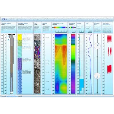
Well Plotter - Data Visualization Software
Data visualization software for wells and boreholes. Program includes functionality for variable data types rendering, such as technical scheme of well, geological scheme, numerical continuous measurements, tectonic and structural data or images. All these data can be simultaneously displayed in one Log Plot. In addition, program includes features to display well positions on multiple map types.

Well Plotter - 3D Well Data Visualization and Rendering Software
Software for well data visualization and rendering in 2D and 3D. Extended version of basic Well Plotter tool. In addition to features in basic edition here are prepared options for displaying of 2D geological schemes and complex 3D fence models. Well Plotter 3D includes all the features from basic Well Plotter software - display your well data on map and in log plot. Description of these features you can find on website about Well Plotter. Well Plotter 3D have two additional display options. One is for 2D geological schemes and the second for complex 3D geological fence diagrams with support of ESRI shapefiles. In 2D geological schemes you can display the course of geological stratas. In the places, where wells are located, you can add other types of data, such as technical scheme of well or chart with your numerical data.
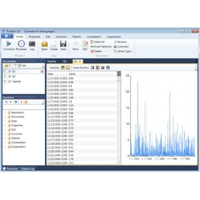
TS Editor - Data Processing Software
Software for hydrological, hydrogeological and meteorological time-series data processing. The flagship of the second generation of the HydroOffice tools. Functionality of this tool is designed for simple and quick time-series processing. In the case you are working in the field of hydrology - environmental engineering - meteorology, this tool can save you a huge amount of time.
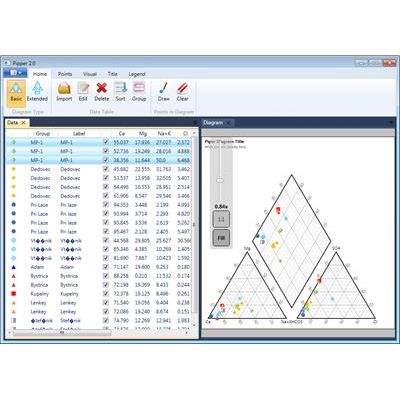
Piper - Geochemical Data Analysis Software
Geochemical data analysis in Piper diagram. Comprehensive tool for creating professional Piper diagram. The program is based on vector graphic rendering and you can visually edit and adjust all the properties. In also contains many new features that you will not find anywhere else. Program also includes extended version of Piper diagram.

Durov - Geochemical Data Comprehensive Tool Software
Plot your geochemical data in Durov diagram. Comprehensive tool for creating a professional Durov diagram. The program is based on vector graphic rendering and you can visually edit and adjust all the properties. It also contains many new features you will not find anywhere else. All three diagram-creation programs (Durov, Piper and Ternary) have the same user interface. Therefore, when you master one tool, you can automatically use the other two. The interface is very simple and logically structured so that all features are quickly accessible, and each program consists of a ribbon toolbar and two documents.

Hydro Office - Professional Ternary Diagram Software Tool
Free software tool for creating professional Ternary diagram. The program is based on vector graphic rendering and you can visually edit and adjust all the properties. Interesting features such as conditional setup of points rendering, vector zoom, direct text editing.