
PCI Geomatics software
Other

PCI Geomatics - Model GXL - GeoImaging Accelerator
Producing professional, seamless and realistic looking 3D landscapes using commercially available imagery is important for flight training and simulation. Several commercial satellite sensors such as WorldView, Pleaides, and SPOT can provide stereo imagery for high resolution Digital Surface Model (DSM) extraction and very high quality ortho production. Using GXL, large blocks of images can be processed to produce DSMs and seamless colour balanced mosaics that can be draped over elevation models covering large areas. GXL also supports processing for high resolution aerial imagery. L3 Link Simulation & Training uses GXL on a regular basis for their flight simulator scenery creation, training pilots for the F-22, F-16, F-18 and other fixed and rotary wing aircraft.
PCI Geomatics - Model HAP - Historical Airphoto Processing System
Historical aerial photography archives contain valuable information that remains untapped. Digitally scanned and properly geo-referenced historical aerial imagery can bring this information to life, making it possible to analyze/visualize the historical information in modern GIS systems. These historical images can reveal hidden patterns, provide a deeper understanding of changes over time thus leading to better decision making.
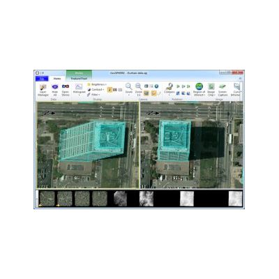
PCI Geomatics - Model 3D FeatureXtract - 3D Modeling Software System
3D FeatureXtract offers efficient and simplified methods for extracting linear and nonlinear features from imagery and generating accurate complex 3D building models. The system uses overlapping aerial and satellite imagery and can quickly extract 3D buildings, roads, and other forms via an intuitive, easy to use interface.