
- Home
- Companies
- PCI Geomatics
- Software
PCI Geomatics software
PCI Geomatics - Model STAX - UAV Image Alignment and Analytics Software
Collecting UAV imagery over the same location can require costly ground control point setting and surveying, and still result in imagery stacks that are slightly misaligned once processed. Ensuring your imagery is accurately aligned is the first and most critical step in performing multi-temporal analytics. With STAX, the alignment process is easy and fully automated. You have the option to supply a reference image of similar resolution with overlapping coverage to align a deep stack of data, or to use one of the images in your stack as a reference. Once you’ve aligned your images, you’ll be able to perform vegetation analysis, produce reports, and accurately measure changes over time.
DataEM - Model LandScapeâ„¢ - Point Cloud Editing Toolkit
Summit Evolution takes 3D stereo vector digitizing to a new level with its integration of digital stereoplotter, CAD and GIS interfaces, 3D stereo vector superimposition, automated feature editing and contour generation.
Bin - Program System for Engineering Applications
A Program System for Close Range Photogrammetry and Aerial Triangulation Including Three-Dimensional Geodetic Network Adjustment. BINGO is a modern and efficient program system for combined photogrammetric geodetic point determination. It can be used for aerial triangulation with large blocks as well as for the terrestrial photogrammetry and the three-dimensional adjustment of geodetic networks. The initial aim of BINGO development was to process photogrammetric geodetic networks for engineering applications of photogrammetry. For this reason a special emphasis was put on a rigorous mathematical model, flexible application possibilities of the functions and a differentiated stochastic model. These principles have been followed during the development of standard aerial triangulation and consideration of the kinematic GPS-positioning. Despite of the wide range of possibilities the program is still easy to handle.
Geomatica
PCI Geomatics - Geomatica for Professional
With thousands of installations in over 130 countries, Geomatica has established itself as the software geospatial professionals around the world trust to solve problems quickly and effectively. Geomatica 2014 adds many new tools and functions to further streamline operational workflows. Combined with improvements to key algorithms, new wizard-based functions, and an expanded list of supported sensors; Geomatica 2014 is our most ambitious release yet.
PCI Geomatics - Geomatica for Education Suite
The increasingly important role of geographic information in almost every academic discipline, coupled with its fast-growing field of high-tech career options, will add a new dimension to a wide variety of academic studies at your institution. Professional grade software that helps your students visualize, research and analyze geographic information demonstrates how important spatial analysis is to sound decision making. Geomatica is used by scientists and image professionals across industries to access, analyze, and share all types of data and imagery. Our Educational software solutions make image analysis and data visualization tools easily available to the academic world.
PCI - Radar Suite
Geomatica Prime includes dozens of algorithms designed specifically for comprehensive radar analysis. SAR segmentation, classification, and feature extraction. Generation of radar brightness. Generation of calibrated radar backscatter. SAR image change detection. Texture Analysis. Multiple SAR speckle filters. Airborne radar processing tools.
Other

PCI Geomatics - Model GXL - GeoImaging Accelerator
Producing professional, seamless and realistic looking 3D landscapes using commercially available imagery is important for flight training and simulation. Several commercial satellite sensors such as WorldView, Pleaides, and SPOT can provide stereo imagery for high resolution Digital Surface Model (DSM) extraction and very high quality ortho production. Using GXL, large blocks of images can be processed to produce DSMs and seamless colour balanced mosaics that can be draped over elevation models covering large areas. GXL also supports processing for high resolution aerial imagery. L3 Link Simulation & Training uses GXL on a regular basis for their flight simulator scenery creation, training pilots for the F-22, F-16, F-18 and other fixed and rotary wing aircraft.
PCI Geomatics - Model HAP - Historical Airphoto Processing System
Historical aerial photography archives contain valuable information that remains untapped. Digitally scanned and properly geo-referenced historical aerial imagery can bring this information to life, making it possible to analyze/visualize the historical information in modern GIS systems. These historical images can reveal hidden patterns, provide a deeper understanding of changes over time thus leading to better decision making.
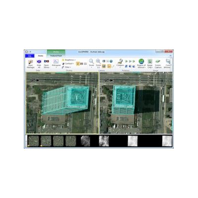
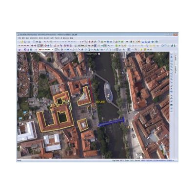
PCI Geomatics - Model 3D FeatureXtract - 3D Modeling Software System
3D FeatureXtract offers efficient and simplified methods for extracting linear and nonlinear features from imagery and generating accurate complex 3D building models. The system uses overlapping aerial and satellite imagery and can quickly extract 3D buildings, roads, and other forms via an intuitive, easy to use interface.