Geospace Survey Services Limited
- Home
- Companies
- Geospace Survey Services Limited
- Products
- Hi-Target - Model iFly U0 - Unmanned ...
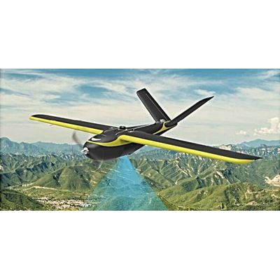
Hi-Target - Model iFly U0 -Unmanned Aerial Vehicle (UAV)
Drones have begun to take over technology now, from play drones and war drones, drones are beginning to find indispensable use in industries, for security surveillance, agricultural purposes, advanced aerial photography and video shoots, and now geophysical survey and mapping etc. We have cutting-edge unmanned aerial vehicles for all these purposes at an affordable price. What is better than having your results in quick and real-time, without spending much energy and finance, and personal safety is one hundred percent.
Most popular related searches
unmanned aerial vehicle
carbon fiber
security surveillance
geophysics monitoring
carbon allowance
geophysics mapping
geophysics
level controller
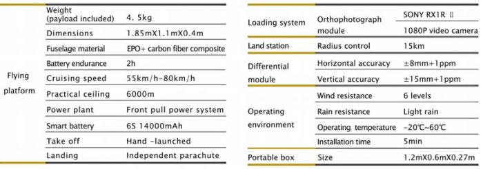
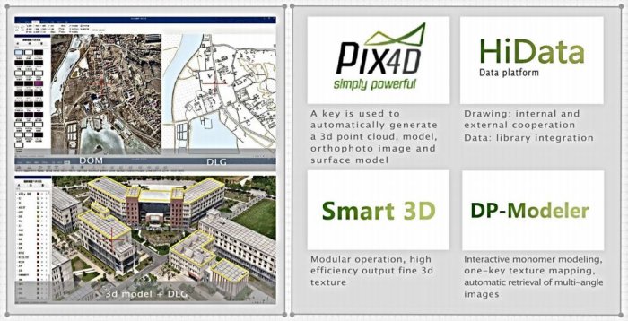
- iFly U0 is a professional intelligent aerial survey UAV system.
- With more than 10 years of flight control research and development technology, operation is very efficient.
- With more than 20 years of high precision RTK research and development technology, the results is very accurate.
- The modular design of composite materials, with EPO+ carbon fiber allows free tool disassembly, easy maintenance.
- With professional, customized ground station software, UAV has seamless connection with the ground station, and operation is simple and efficient.
Long-endurance
- Long-endurance 2 hours, flies more efficiently.
High precision
- Multi-star multi-frequency, centimeter-level positioning, no photo-control point measurement.
Modular design
- No tools, one minute disassembly, easier maintenance.
Multiplexed parachute
- Modular parachute, quick change, efficient operation, reuse and save costs.
One-person operation
- Hand -launched takeoff, intelligent flight, fixed parachute drop, easy to operate and convenient to carry.
Smart battery
- Intelligent monitoring, maintenance free, safe and reliable, long life.