

Geospace Survey Services Limited products
Seismograph - Seismology
Seismic Reflection Technique
The seismic reflection technique maps the subsurface stratigraphy based on density and velocity contrasts between earth materials. The seismic wave, generated at the ground surface, travels through the earth and is reflected an interfaces where a change in density and velocity occurs. The reflected waves are detected by a geophone array and recorded by a seismograph.
Seismic Refraction Technique
The refraction method uses seismic waves, introduced into the ground by a weight-drop source, to determine the compressional velocity of earth material. The seismic wave changes direction and speed, or refracted, as it propagates through the earth. When the refracted seismic wave impinges on an interface at a critical incident angle, the energy travels along the interface and sends seismic wavelets back to the surface. Geophones placed at selected intervals along the ground surface detect the ground motion and send an electrical signal, via a cable, to the seismograph. The seismograph digitizes, amplifies, filters and records the incoming signals. Analysis of the arrival times of the refracted wave provides a means for calculating the seismic velocity and modeling depths to subsurface layers.
Seismograph
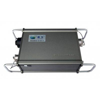
Model GS101 - Distributed High Precision Land Seismograph
GS101 distributed high precision land seismograph adopt the 32-bit high precision Σ -Δ ADC. It supports ten thousand channel 2D and 3D seismic exploration. The instruments contain industry PC, master station, cross station, acquisition station. The connection structure is very flexible and light. Exploration depth can reach from several meters to thousands of meters. This instrument is applicable to the seismic work such as reflection, refraction, surface wave exploration, pile foundation inspection, pulse, seismic imaging, vibration measurement and wave velocity (shear wave) test etc. The instrument has been widely used for different areas engineering geological exploration such as water conservancy, electricity, roads, railways, bridges, urban construction, transportation, groundwater and resources exploration such as oil, coal, coal-bed methane, shale gas, metals and non-metallic mineral.
Unmanned Aerial Vehicle
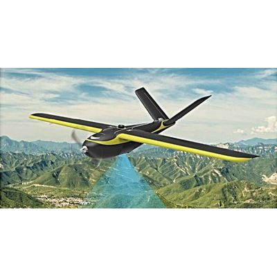
Hi-Target - Model iFly U0 - Unmanned Aerial Vehicle (UAV)
Drones have begun to take over technology now, from play drones and war drones, drones are beginning to find indispensable use in industries, for security surveillance, agricultural purposes, advanced aerial photography and video shoots, and now geophysical survey and mapping etc. We have cutting-edge unmanned aerial vehicles for all these purposes at an affordable price. What is better than having your results in quick and real-time, without spending much energy and finance, and personal safety is one hundred percent.
GS101 Accessories
Model L8-50 - 50m Digital Composite Cables
50m digital composite cables. Industrial cable, waterproof plug, 8 channels and 6.25m channel spacing.