- Home
- Companies
- Geovariances
- Services
- Geovariances - Consulting and Mentoring ...
Geovariances - Consulting and Mentoring Services
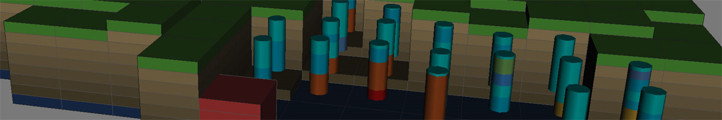
MINING
We help you improve production and economic performance.
Our services include:
– Geological and metallurgical domain definition using machine learning techniques,
– Resource estimation and classification (according to NI 43-101 and JORC, among others),
– Optimization of short, medium, and long-term estimates,
– Recoverable resource estimation (estimation of tonnage, metal quantity, and grade above chosen cutoffs) and SMU modeling,
– Resource uncertainty characterization,
– Drill hole spacing optimization.
CONTAMINATED SITES AND NUCLEAR DECOMISSIONING
We help you design more effective remediation and decommissioning scenarios.
Our services include:
– Detailed data analysis and quality control and delivery of critical statistics,
– Optimization of investigation density and location,
– Delimitation of contamination sources and concentrated pollutions,
– 3D modeling of deep contamination
– Quantification of masses of contaminants and volumes of soil to be treated according to remediation thresholds,
– Classification of contaminated areas and wastes with a quantified risk analysis,
– Optimization of waste treatment routes,
– Sizing of management solutions (mass balance, cost-benefit balance, excavation maps, etc.).
GEOTECHNICAL ENGINEERING
We help you improve your understanding of ground conditions and better handle risks.
Our services include:
– 3D modeling of the geology and geotechnical parameters,
– Subsurface variability characterization,
– Geotechnical risk characterization with the delivery of several scenarios (for example, of the parameters measuring the geomechanical constraints or soil deformation),
– Modeling of aquifer geometry,
– Optimization of measurement networks.
OIL AND GAS
We help you assess better the economic viability of your project.
Our services include:
– Filtering of acquisition or processing artifacts in seismic cubes,
– Merging of seismic cubes,
– Time-to-depth conversion,
– Definition of stratigraphic units,
– Lithofacies and geologicy modeling,
– Assistance in petrophysical and geomechanical modeling,
– Geobodies connectivity analysis,
– Identification of spill points and delineation of potential reservoir traps,
– Production of various scenarios of potentially recoverable resources and gross rock volumes.
AIR, WATER, SOIL, BIORESOURCES, AND OTHER SECTORS
We help you reveal the information behind your data.
Our services include
– Air quality monitoring: mapping of pollutants, air quality indices or population exposure to air pollution, optimisation of measurement networks.
– Bathymetry: seabed mapping, uncertainty analysis.
– Bioresources (forestry, fishery, ..): stock assessment, health risk evaluation.
– Precision agriculture: yield mapping, identification of homogeneous areas.
– Any sector dealing with spatial data, i.e. climatology, geochemistry, epidemiology, archaeology: mapping, risk analysis.
AUTOMATION, CUSTOMIZATION AND REVIEW OF WORKFLOWS
We help you be more efficient with our software solutions and quickly deliver the results your company expects.
Our services include:
– Automation of estimation routines,
– Optimization of estimation parameters,
– Review and optimization of your current process,
– Converting routines from Isatis or other software to Isatis.neo,
– Building and delivery of workflows using Isatis.neo and Python packages,
– Mentoring to assist you in setting up your workflow based on your data and objectives.