

- Home
- Companies
- Ambiental Risk Analytics
- Services
- FloodScore - Property-Level Flood Risk ...
FloodScore - Property-Level Flood Risk Scores Assess and Flood Risk Information Services
FloodScore uses the advanced flood modelling techniques developed for UKFloodMap4™. It incorporates the most current hydrology data from the Centre of Ecology & Hydrology, building stock data from Ordnance Survey, and the latest high resolution LiDAR from the Environment Agency.
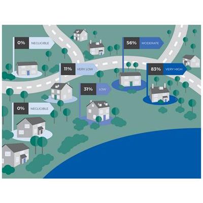
This data is used to formulate a risk index, which reflects the average annual loss (AAL) for a property. This ‘flood score’ takes into account the likelihood of an individual property being flooded due to rainfall, overflowing rivers or tidal surges, as well as the damageability for different property classes. To improve the stability and accuracy of the flood scores, they’re derived from a range of return periods (1 in 30, 75, 100, 250, 500 and 1000 year scenarios), along with complex risk-scoring algorithms.
- Less time needed to assess flood risk
- Better accumulation control
- More consistent flood underwriting
- Constant access to the most current available data