

- Home
- Companies
- EarthSoft, Inc
- Software
- EarthSoft - Version EQuIS Geotech - ...
EarthSoft - Version EQuIS Geotech -Geotechnical and Environmental Data Management Software Suite
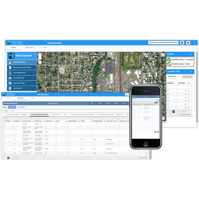
EQuIS Geotech extends the EQuIS software suite and manages geotechnical and environmental data in a single enterprise solution. EQuIS Geotech integrates mobile field data collection with EQuIS Collect, efficient manual data entry (Web Forms), and laboratory and instrumentation Electronic Data Deliverables (EDDs). Furthermore, EQuIS Geotech stores raw lab data, integrates with GIS/CAD applications to generate a wide array of configurable reports, and can connect to internal Enterprise Resource Planning (ERP) systems through a REST API. Numerous native EQuIS data operations are directly integrated, including migration capabilities and visualization tools. EQuIS Geotech improves data quality and streamlines project workflows for large-scale geotechnical data management.
Project Planning
- Setup project information
- Project planning workflows include standard EQuIS project setup and optional connections to client applications using REST API
- Prepare exploration plans, including proposed boring locations, methods, and depths (etc.)
- Schedule and disseminate the exploration plans to the field crew
Field Activities & Data Collection
- Capture drill sample information on paper or with EQuIS Collect
- Field logs are entered into browser-based Web Forms, conforming to organizational data standards
- Load cone penetrometer test (CPT) and dilatometer test (DMT) data
- Web Forms are configurable for efficient data entry and various data types
Boring Log Data Review
- Quickly generate soil boring logs and profiles, CPT logs, and DMT logs to review subsurface site conditions
- Map and grid-based filtering to review boring log data
- Review and modify data to reflect observed subsurface conditions
Lab Assignments & Testing
- Assign required lab testing based on project requirements and observed field results
- Assign labs and associate corporate, regional office, or project lab fees
- Lab forms support electronic import or hand entry of lab results
- Store raw lab data and reporting calculations directly in EQuIS Geotech
- Lab data review templates include Atterberg limit, grain size, water content, and more
Instrument Data
- Batch load instrumentation data files using configurable data templates
- Review and report UU/UC and more
Analyze Visualize & Report
- Review and analyze data through multiple reports and templates
- REST API integrations with Esri’s ArcGIS for spatial analysis and reporting
- Produce presentation quality deliverables fit for final reports
Standard Reports
- Boring, CPT, and DMT Logs
- Subsurface Profile
- AGS 4 Export
- Atterberg Limits – ASTM D4318
- Particle Size Analysis – ASTM D422
- Sieve Analysis – ASTM D6913
- Hydrometer Analysis – ASTM D7928
- Unconfined Compression – ASTM D2166
- Unconsolidated Undrained – ASTM D2850
- Compaction – ASTM D698/D1557
- Grain Size Analysis – AASHTO T-88
- Geotechnical Lab Summary
- Geotechnical Lab Forms
- gINT Export
- CAD Exports (DXF, DWG, DGN, etc.)
- and more….