

Spatial Wave, Inc.
- Home
- Companies
- Spatial Wave, Inc.
- Software
- GeoMerge - Rule-Based GIS Data Merging ...
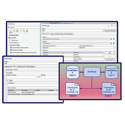
GeoMerge - Rule-Based GIS Data Merging Tool
GeoMerge is a robust, yet simple, and most of all, reliable software for ensuring that your data synchronizations are done accurately and quickly. GeoMerge is an add-in to ArcGIS Pro programmatically synchronizing two layers/tables using rule-based instructions. GeoMerge uses the user-defined rules when synchronizing the data to resolve the conflicts. This allows for a flexible configuration so the end-user can identify the conditions under which a record is updated, inserted, or removed from the destination.
Most popular related searches
GeoMerge supports all versioning models supported by Esri, including the new branch versioning, which is used in Utility Network and Parcel Fabric. It includes support for expressions that could be used to transform the data on the fly or in the rules logic.
GeoMerge includes support for the following source or destinations:
- Enterprise geodatabase
- File geodatabase
- OLEDB (SQL, Oracle, DB2)
- SQLite – Including Mobile GDB
- Feature service – Including branch versioning
- Shapefile
GeoMerge is an ideal tool to maintain a geodatabase synchronized with another geodatabase, an external spatial (e.g., SQL Spatial), or a non-spatial database (Oracle table).
- Merge data between geodatabases & tabular databases
- Simplify maintaining your most up-to-date data against external sources
- Captures & reports results for every execution
- Maintain & keep your utility network databases up-to-date
- Supports a variety of source & destination formats
- Can be used by DBAS, GIS teams, asset managers & more
- Use rules to implement a complex data merging scenario
- Run batch merges operations on schedule