
- Home
- Companies
- RockWare, Inc.
- Software
RockWare, Inc. software
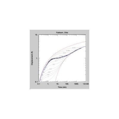
AQTESOLV - Aquifer Test Software
AQTESOLV is used for the design and analysis of aquifer tests, including pump test, step-drawdown tests, variable-rate tests, recovery tests, single-well tests and slug tests. AQTESOLV offers sophisticated options for a vast array of aquifer test solutions for confined, unconfined, leaky and fractured aquifers,
ChemPoint & ChemPoint Professional - Environmental Data Management Software
ChemPoint is the complete data management and reporting solution for air, soil, surface water, ground water, ash, sludge, and bio-tissue analysis data, and comes with the following features.
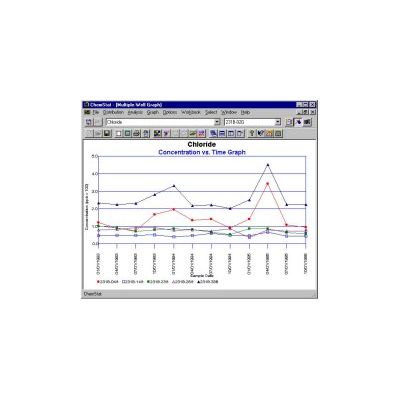
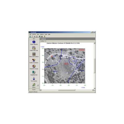
ChemStat - Environmental Statistical Analysis Software
ChemStat is the easiest and fastest application available for the statistical analysis of ground water monitoring data at RCRA facilities. ChemStat includes most statistical analysis methods described in the 1989 and 1992 USEPA statistical analysis documents, USEPA Draft Unified Guidance Document, U.S. Navy Statistical Analysis Guidance document, and other guidance documents and methods documented in popular statistical texts. A unique combination of ease-of-use and innovative technologies make ChemStat the value leader for environmental statistical analysis.
CAD2Shape - CAD to Shapefile Converter
Convert AutoCAD DWG / DXF to ESRI Shape (.shp). CAD2Shape converts AutoCAD DXF or DWG formats to ESRI Shapefiles (ArcGIS, ArcMap, ArcView etc.). The software is completely stand alone (does not require ArcGIS, ArcMap, ArcView) The software lets the you tailor the conversion to suit your needs. CAD2Shape is a perfect DXF to shapefile converter software. Converting CAD to GIS tutorials are available for CAD2Shape users. With CAD2Shape, you do not need to convert dwg to shp by using QGIS or export shapefile from AutoCAD Civil 3D anymore.
Arcv2CAD - Shapefile to CAD Converter Software
Arcv2CAD: Convert ArcView shapefile (.shp) to AutoCAD dwg/dxf. Arcv2CAD converts all ESRI ArcGIS 2D/3D Shapefile (Multipatch, Polygon, Points, Lines) to AutoCAD DXF, DWG or KML. Completely stand alone (does not require ArcGIS or AutoCAD). Convert Text Labels, Legends, Table data, Elevation data, colors and layers from Shapefile to AutoCAD DXF, DWG or KML. Convert multipatch and 2D/3D polygon to 3D objects in AutoCAD. Batch Conversion. Layer control determines layer names and selects entities on layers. Select Shapefile feature attributes to convert to DWG, DXF or KML. and more…
CAD Viewer - CAD Viewing and Annotation Software
All the tools you need for CAD viewing and annotation. CAD Viewer is a DXF and DWG viewer that is designed to be especially easy to use for the non-CAD user, but even CAD professionals will appreciate features such as Back and Forward browsing, and multiple file selection and batch printing. CAD Viewer supports all DXF and DWG versions through to AutoCAD 2018.
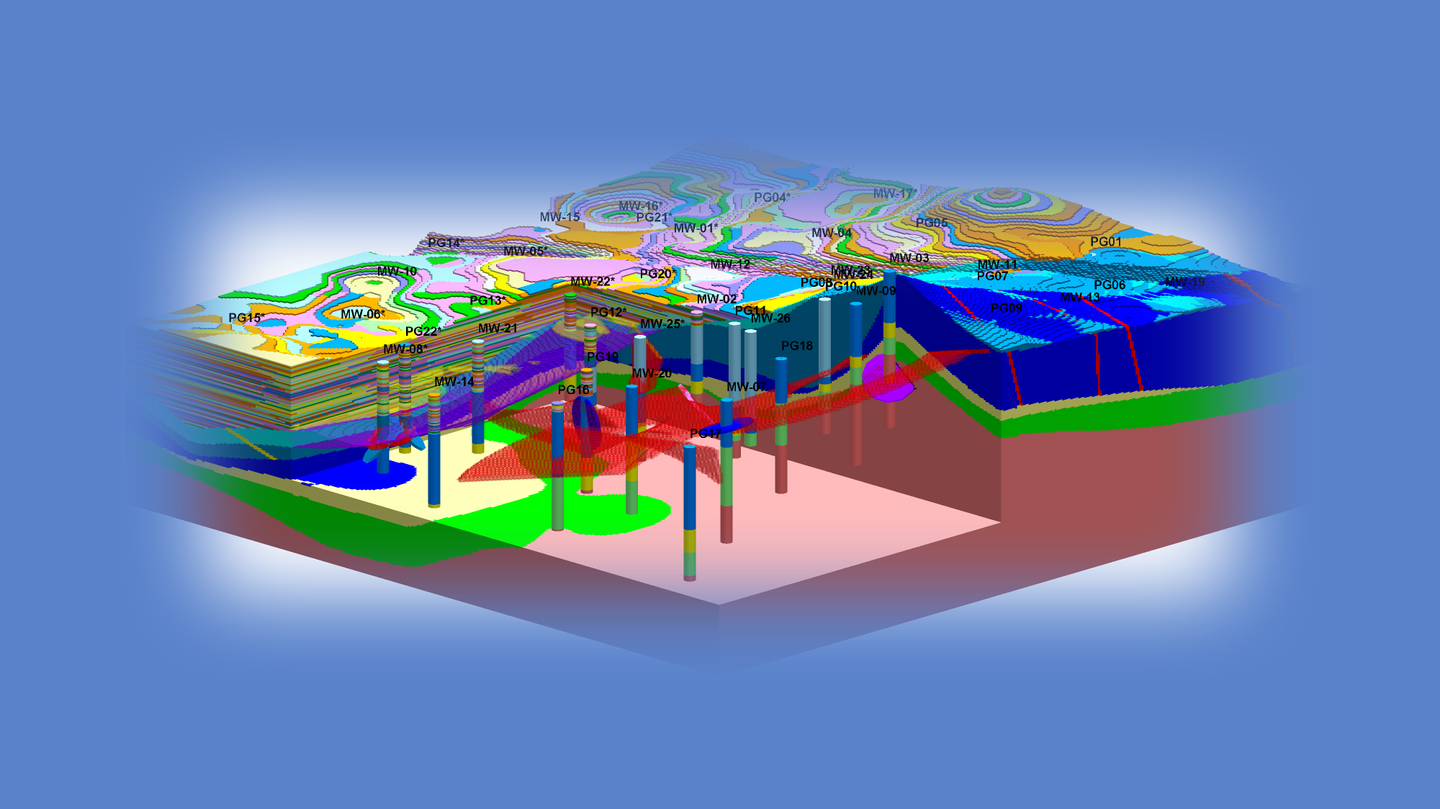
EQuIS - Environmental Data Management Software
EQuIS has long been the standard for managing environmental data. Used around the world by regulators, consultants, and industrial companies, EQuIS makes accessing, analyzing, and viewing environmental and geotechnical data easy and efficient. Benefits are realized from small sites that may require only a few borehole logs to large remediation projects that involve geologic cross-sections, groundwater models, fate and transport, solid models, contours, and reports. EQuIS eliminates the tedious and error-prone management tasks that often exist when data are on paper or in separate spreadsheets. EQuIS is an environmental data management system with advanced links to ArcGIS, LogPlot and RockWorks.
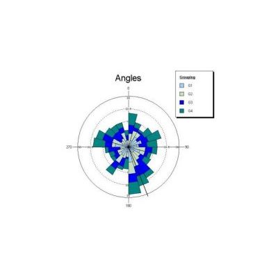
Oriana - Circular Data Statistics Software
Oriana for Windows calculates the special forms of sample and inter-sample statistics required for circular data. It also graphs your data in a variety of ways, allowing you to easily demonstrate patterns. These analyses and graphs are rarely found in other statistical packages.
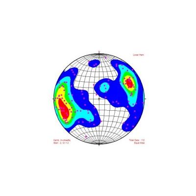
StereoStat - Stereonets and Rose Diagrams Software
StereoStat is an integrated platform for organizing, manipulating, visualizing and interpreting geological datasets. Functionality includes: Flexible and easy-to-use data importer. Full color plotting. Comprehensive data manipulation and organization. Statistical analysis. StereoStat is must-have software for anyone who needs high quality rose diagram, stereo and tangent plots.
Civil Engineering
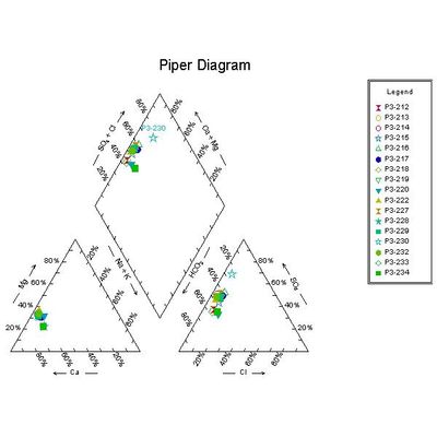
RockWare - Model AqQA - Software for Water Analyses
Software for water analyses: unit conversion, ion balance, sample mixing, basic fluid properties calculations, water chemistry diagrams (Piper, Stiff), and more. Imagine you could keep the results of your chemical analyses in a spreadsheet developed especially for the purpose. A spreadsheet that knows how to convert units, check your analyses for internal consistency, graph your data in the ways you want it graphed, and so on.