

- Home
- Companies & Suppliers
- Downloads
- Gobi - Solar Collectors - Brochure
Advanced Geophysical Operations and Services Inc. (AGCOS) software
Special Software
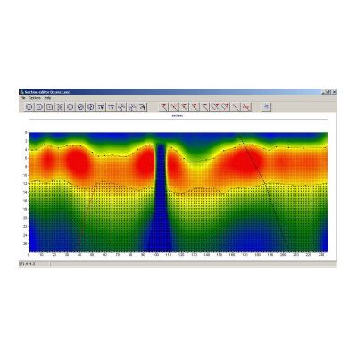
Model SectionEditor - Software for Geological-geophysical Section Creation
SectionEditor software is designed to transform geological section into geophysical one using apriori information. The SectionEditor program allows to quickly build geological cross-section based on the interpretation of the profile obtained in the Zond Software Package. The program uses scalable image format SEC as initial data, which can be exported from any Zond interpretation programs. The results of the interpretation serve as the color background on which to build the geological model. During model creation, local objects and layers are selected, which are then applied to the specified by interpreter geological specks. The program also allows to display the well data, which greatly simplifies the process of model building.
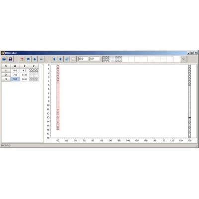
Model BHEditor - Software for Lithological Columns Creation
BHEditor software is designed to geologically understand sections obtained with Zond software. In many cases, the binding of geophysical results is produced by the lithological columns or logs. Therefore, ability to display different types of apriori information during the geophysical interpretation of the data is very important.

Model Z3DModView - Software for 3-D Visualization of 2-D Inversion Results
The Z3DModelView program is designed for three-dimensional visualization of the results of relevant one or two-dimensional interpretation of the data obtained in the Zond inversion software. For geophysical surveys, measurements are usually performed by a system of parallel profiles. To better understand the structure of the survey area, it is convenient to construct such data in three dimensions. Such approach allows to effectively meet the challenges of correlation structures for parallel profiles, compare profiles to perpendicular profiles at the intersections, build horizontal sections for a given depth (several depth slices).