

Advanced Geophysical Operations and Services Inc. (AGCOS) software
Zond Software - Potential Methods
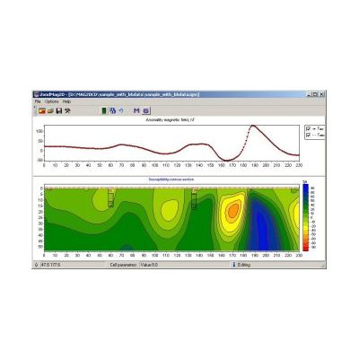
Model ZondMAG2D - 2D Gravity and Magnetic Interpretation Software
The program is designed for 2D magnetic and gravity 2D modeling and interpretation in two (2) versions: land/surface; airborne. Single and easily understandable data format is used in the program, but main known data formats are supported.
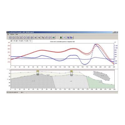
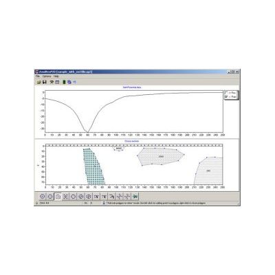
Model ZondPGM - 2D Gravity and Magnetic Interpretation Software in Polygonal Way
ZondPGM is designed for 2D interactive and automatic 2D gravity and magnetic data interpretation in ground and airborne versions. In comparison to ZondMAG2D program, ZondPGM uses the polygonal way of describing petrophysical medium. Such approach provides some advantages for data interpretation. The primary model construction is accomplished via creation of a number of closed polygons of somewhat limited geometry with stable magnetic or gravity properties inside each polygon. Due to very convenient interface it is possible to very quickly create complicated model. Calculations take into account the host rocks properties, as well as surface topography, full magnetic field vector inclination, regional anomalies, etc.
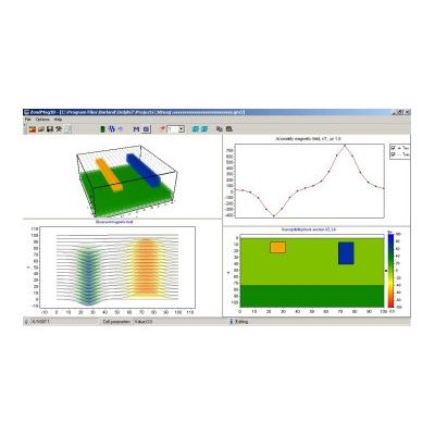
Model ZondMAG3D - 3D Gravity and Magnetic Interpretation Software
ZondMAG3D is designed for 3D modeling and inversion of surface and airborne gravity and magnetic data. Program has convenient interface and extensive reporting capabilities. Simple and understandable data format, which allows to easily combine different observation system data. Main well-known data formats are also supported.
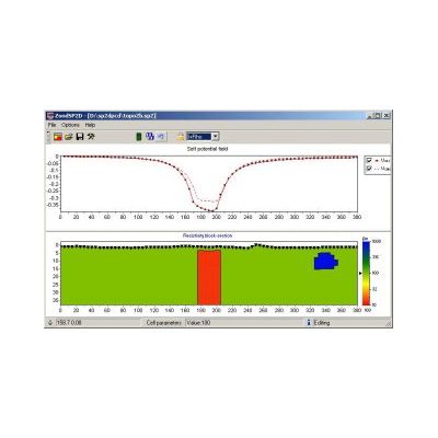
Model ZondSP2D - 2D Electric Self Potential Data Interpretation Software
ZondSP2D program is designed for Self Potential (SP) method 2D data interpretation. The medium model is created through a number of cells. Each cell has the resistivity value and type of conductivity (ion or electronic) properties. Sources of SP field are installed at the borders of the cells with different type of conductivity. The size of the cells is decreasing with depth, as it is connected to the sensitivity of the method.
Model ZondSP2Dp - 2D Electric Self Potential Data Interpretation Software in Polygonal Way
ZondSP2D is designed for 2D interpretation of SP surface or borehole data for mining applications. In comparison to ZondSP2D, this program uses polygonal way to describe geoelectrical medium. This way allows to take structural approach to data interpretation. The 2D section of each body is described by close polygonal contour (polygon). The interpreted model has been described by a number of closed polygons with free geometry, with known resistivity and type (electronic or ionic) of conductivity. The software has very convenient interface. The calculations take into account the coordinates of electrodes as well as topography.