

Stone Environmental, Inc. (SEI) services
Agrochemical Fate and Exposure Services
Surface Water Monitoring Services
Between the edge of a farm field and a downstream water treatment plant is a network of drainage ditches and streams. We monitor the water and biota in these perennial streams to assess the potential impact of pesticides on aquatic animals and plants. We conduct stream sampling at this intermediate scale, where environmental concentrations of a pesticide need to be measured for comparison with ecotoxicological levels of concern.
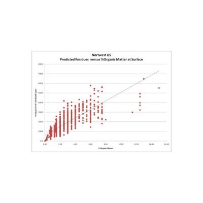
Environmental Fate Modeling Services
Since 1992, Stone has been assisting agrochemical clients with the registration of new chemicals, and the maintenance and mitigation of existing registrations. As a critical part of every registration project, our modeling team is one of the most experienced in the industry in predicting the environmental concentrations of an agrochemical in surface water and groundwater.
Edge-of-Field Runoff Studies Services
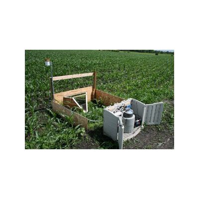
Stone has conducted nine studies quantifying runoff losses of crop protection and lawn care chemicals following rainstorms and irrigation. The objective of these studies was to assess the runoff potential of pesticide products under actual use conditions. In our most recent study, we qualified and instrumented 20 sites throughout the Midwest, trained contractors and growers to collect samples, and managed all sampling activities for the duration of the growing season. We set up more than 100 siphon-type runoff collectors at the sites, and instrumented five sites with Sigma autosamplers and tipping bucket rain gauges.
Simulated Rainfall Runoff Studies Services
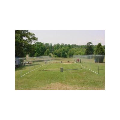
Relying on natural rain can be problematic and expensive for those conducting a runoff study. Everyone in the industry knows of a runoff study in which no runoff was generated, or, conversely, in which a massive event wiped out sampling equipment, ruining the experiment. Getting a natural runoff event of appropriate magnitude within a specific time period following product application is a matter of luck. Use of a rainfall simulator eliminates the risks associated with fickle weather, providing control over the timing, intensity, and duration of rain.
Community Drinking Water Monitoring Services
With 13 drinking water monitoring studies successfully implemented and 11 completed, we have led the industry in conducting such studies since 1994. These studies have involved several hundred community water systems (CWSs) across the US. We have worked with the Acetochlor Registration Partnership on the largest such study yet conducted, which involved almost 200 CWSs and spanned a period of seven years. Our smallest study involved just five systems sampled over the course of a year to address a product registration issue in a specific region.
Applied Information Management Services
GIS and Database Application Development Services
The data analysis techniques that GIS can provide are more powerful and cost effective when users can apply them repeatedly for varying situations. We make this possible by writing customized GIS tools and applications for our clients. We start by fully understanding the user`s needs and defining the workflow. Next, we develop and test the spatial analysis technique that will form the basis of the application. Once the client approves the technique, we develop a flexible, user-friendly interface that matches our client`s workflow. Our customized GIS tools and applications empower our clients to efficiently perform complex spatial assessments, giving them more time for evaluating the results.
Spatial Analysis Services
Whether the challenge is identifying watersheds vulnerable to pesticide exposure or determining the onsite wastewater treatment capacity of a new neighborhood development, or understanding the volume of food scraps available to supply composting sites or where can proposed wind towers be seen from, spatial analysis using GIS enables the integration of complex data sets to support environmental decision making.
Information for Sustainable Development (ISD) Services
Baseline Data Collection and Multi-Sector Country Profiles Services
To monitor project and program effectiveness, it is essential to develop a baseline of information to see if progress is being made. Stone uses baseline data to profile current conditions, and compares all new data to the baseline to measure change. We have developed methods that portray existing information in a ready-to-use format for identifying current status. Our design anticipates the capture of new program data or ongoing data collection activities to help clients easily complete future evaluations. We have conducted numerous baseline data collection projects concerning natural resource management, environmental trends, and socioeconomic conditions.
Needs Analysis and Implementation Solutions Services
Where does GIS make sense? A needs analysis is the first step in implementing a Geographic Information System (GIS) in any organization. It is a systematic look at how user groups function and what skills, spatial data, and software tools they need to succeed in their work. At the conclusion of a needs analysis, we provide the organization with the technical and implementation plans necessary to develop a Geographic Information System. In addition to providing this information, a GIS needs analysis fosters cooperation and enhanced communication between user groups.
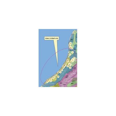
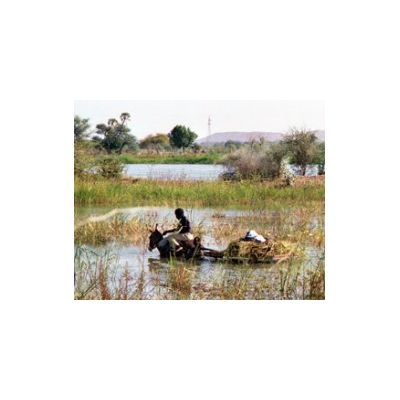
Poverty Mapping and Vulnerability Assessment Services
Developing a baseline for understanding what areas are poorest and how to measure progress is an important first step in improving the standard of living of vulnerable populations. The process we use is simple. First we identify and map all the relevant indicators of poverty that are available in a country’s databases. Then we compile and integrate the data sets in a spatial information system. Finally, we analyze the data and create an interactive Geographic Information System (GIS) consisting of social, economic, environmental, and natural resource information. Stone Environmental has been conducting poverty mapping and vulnerability assessments for a number of years and has completed three related projects in Niger for the World Bank and a similar project in Mali for USAID. These efforts provided countries and donors with objective ways to measure poverty to implement better and more equitable investment policies to achieve poverty reduction.